The smallest districts in India rarely make headlines, yet some are tiny enough to drive across in minutes. Mahe holds the title, a former French enclave of Puducherry that covers about 9 square kilometres and sits entirely inside Kerala. Yanam, Central Delhi, Lakshadweep and Diu follow close behind. Why do such small units exist at all? Mostly because of colonial history, island geography and the needs of a capital city. Below you will find a ranked table, a profile of every district with area and population, and a plain explanation of why sources disagree on the numbers.
Smallest Districts in India: Comparison Table
Areas follow the figures most often printed in district profiles. Population comes from the 2011 Census, the last full count. Where sources disagree, the alternative figure sits in the notes column.
| Rank | District | State / UT | Area (sq km) | Population (2011) | Note |
|---|---|---|---|---|---|
| 1 | Mahe | Puducherry | 8.69 | 41,934 | Often rounded to 9 sq km |
| 2 | Yanam | Puducherry | 20 | 55,626 | One census listing shows 30 sq km |
| 3 | Central Delhi | Delhi | 23 | 578,671 | Some pages say 25 sq km |
| 4 | Lakshadweep | Lakshadweep | 32 | 64,473 | Land area, 32.62 sq km by one count |
| 5 | New Delhi | Delhi | 35 | 133,713 | Home to Connaught Place |
| 6 | Diu | Dadra and Nagar Haveli and Daman and Diu | 40 | 52,074 | Diu Island alone is 38.8 sq km |
| 7 | East Delhi | Delhi | 49 | 1,707,725 | Headquarters at Preet Vihar |
| 8 | North East Delhi | Delhi | 56 | 2,240,749 | Another page lists 62 sq km |
| 9 | North Delhi | Delhi | 59 | 883,418 | Boundaries shifted in 2026 |
| 10 | Daman | Dadra and Nagar Haveli and Daman and Diu | 72 | 191,173 | Split by the Daman Ganga river |
Screenshot suggestion: Add a map of India with the four locations that sit far from each other (Mahe, Yanam, Lakshadweep, Diu) pinned and labelled. A Google My Maps export or a screenshot from the Survey of India portal works well here.
One caveat before we go further. Delhi went from 11 to 13 revenue districts on 1 January 2026, so the Delhi figures above reflect the older boundaries. The three new districts (Old Delhi, Central North Delhi and Outer North Delhi) were carved out of existing ones, and I could not find published area figures for them yet. They may well nudge this ranking once official numbers appear.
The 10 Smallest Districts in India, Profile by Profile
1. Mahe, Puducherry
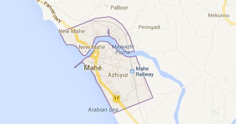
- Area: 8.69 sq km (commonly quoted as 9)
- Population (2011): 41,934
- Density: about 4,659 people per sq km
- Neighbours: Kannur district on three sides, Kozhikode on the fourth
- Literacy: 98.35%
Mahe, known locally as Mayyazhi, is the smallest of all the smallest districts in India, and it is not even close. Kerala wraps around it completely, yet it belongs to the Union Territory of Puducherry, which means a Malayali town reports to an administration far away on the Coromandel coast. The British returned it to the French in 1785, and that colonial footprint explains today’s odd map.
Its population of roughly 42,000 compares with that of Liechtenstein, a fun comparison for a place you can cross in a short walk. Keep one thing in mind, though. Wikipedia’s national list describes Mahe and Yanam as census districts rather than administrative districts, so their status is a little unusual.
Screenshot suggestion: Insert a satellite view of Mahe, with the Mahe river estuary and the surrounding Kerala boundary visible.
2. Yanam, Puducherry
- Area: 20 sq km (30 sq km in one census listing)
- Population (2011): 55,626
- Location: North bank of the Godavari, just south of Kakinada port
- Majority religion: Hinduism, at 96.24%
Yanam is another piece of Puducherry stranded inside a bigger state, this time Andhra Pradesh. Telugu is its official language, which tells you more about the place than any border line does. The Coringa mangroves fall within its administrative reach, and the Yanam Obelisk Tower was built to give visitors a bird’s eye view of that forest.
Notice the area gap between sources. Twenty square kilometres is the figure on the district page; 30 shows up in a census-based list. I would lean toward the official one.
3. Central Delhi, Delhi
- Area: 23 sq km (25 on some pages)
- Population (2011): 578,671
- Headquarters: Daryaganj
- Boundary: Yamuna on the east
Central Delhi proves that small does not mean empty. Wikipedia’s national list names it the densest district in India, at about 25,759 people per sq km. Old markets, government offices, and the Yamuna bank all squeeze into an area smaller than many university townships.
4. Lakshadweep
- Area: about 32 sq km of land
- Population (2011): 64,473
- Capital: Kavaratti
- Inhabited islands: ten
The entire Union Territory counts as a single district, which makes Lakshadweep a special case. Land area is tiny, yet the sea around it is enormous: a lagoon of roughly 4,200 sq km, territorial waters of 20,000 sq km and an exclusive economic zone near 400,000 sq km. Bitra, the least populated inhabited island, had just 271 residents in 2011.
So the “smallest” label depends on what you measure. By land, Lakshadweep is minuscule. By ocean, it is among the larger administrative units in the country.
Screenshot suggestion: Add an official Lakshadweep island map from lakshadweep.gov.in showing the ten inhabited islands.
5. New Delhi, Delhi
- Area: 35 sq km
- Population (2011): 133,713
- Headquarters: Connaught Place
- Sub-divisions: New Delhi and Delhi Cantonment
The New Delhi district covers the planned core of the capital, the Lutyens’ zone of wide avenues and ministries. Its population is low because few people live in government bungalows, embassies and cantonment land. Footfall, however, is another story.
6. Diu, Dadra and Nagar Haveli and Daman and Diu
- Area: 40 sq km (Diu Island is 38.8)
- Population (2011): 52,074
- Literacy: 83.46%
- Extra: Includes the exclave of Simbor, about 25 km east of Diu town
Diu sits off the Gujarat coast and has been part of the merged Union Territory of Dadra and Nagar Haveli and Daman and Diu since 26 January 2020. Diu Fort is the most visited landmark. The district also ranks as the tenth least populated in the country, according to its Wikipedia page.
7. East Delhi, Delhi
- Area: 49 sq km
- Population (2011): 1,707,725
- Headquarters: Preet Vihar
East Delhi lies across the Yamuna from the old city. More than 1.7 million people live here, which makes it a heavyweight in people and a lightweight in land.
8. North East Delhi, Delhi
- Area: 56 sq km (62 on its Wikipedia page)
- Population (2011): 2,240,749
- Density: about 36,155 people per sq km
At 2.24 million people, this district has a population close to that of Latvia. Pack that into 56 square kilometres and you get one of the highest densities of any district in the country.
9. North Delhi, Delhi
- Area: 59 sq km
- Population (2011): 883,418
North Delhi covers the old walled-city fringe and parts of the north. Its boundaries are the ones most likely to move after the 2026 reorganisation, so treat these numbers as provisional.
10. Daman, Dadra and Nagar Haveli and Daman and Diu
- Area: 72 sq km
- Population (2011): 191,173
- Density: about 2,655 people per sq km
- Headquarters: Daman
The Daman Ganga river divides the town into Nani Daman (Little Daman) and Moti Daman (Big Daman). Besides being the administrative capital of its Union Territory, the district grew by more than 69% between the 2001 and 2011 censuses, a pace that suggests industry and migration at work.
Why Are the Smallest Districts in India So Small?
Three patterns explain almost everything.
- Colonial leftovers. Mahe and Yanam survived as French pockets, and Diu and Daman stayed Portuguese until 1961. After independence, those scraps kept their identity as separate administrative units.
- Island geography. Lakshadweep has no neighbouring land to merge with, so a single district covers all of it.
- City administration. Delhi splits a dense urban core into many small districts so each magistrate can handle a manageable crowd.
Notably, all ten districts above belong to Union Territories. No state district comes close. That pattern fits the source data I reviewed, though the 2026 changes in Delhi could reshuffle the lower half of the list.
Why Do Area Figures Differ Between Sources?
You will see Mahe listed as 8.69, 9, and even 10 sq km depending on where you look. Rounding explains some of it. Different survey years and different definitions of land versus total area explain the rest. Yanam shows the same issue, with 20 and 30 both in circulation.
My advice: pick one source, say the Census of India or the district’s own government site, and stay with it across a whole table. Mixed sources create false rankings, especially around the 20 to 35 sq km range, where Yanam, Central Delhi, Lakshadweep, and New Delhi bunch together.
Smallest District in Each Major State
Union Territories dominate the national list, so state-level comparisons tell a different story.
| State | Smallest district | Area (sq km) |
|---|---|---|
| Goa | North Goa (smaller of two districts) | 1,736 |
| Andhra Pradesh | Visakhapatnam | 1,048 |
| Gujarat | Dang. | 1,764 |
| Karnataka | Bengaluru Urban | 2,190 |
Goa is an interesting case. It has only two districts, and even its smaller one, North Goa, is about 200 times the size of Mahe. Meanwhile, Andhra Pradesh’s Visakhapatnam, at 1,048 sq km, is the smallest of that state’s current districts after the 2022 reorganization.
Smallest vs Largest: How Big Is the Gap?
Kutch in Gujarat measures 45,652 sq km, the largest district in India. Mahe measures 8.69. Divide one by the other, and Kutch is more than 5,000 times bigger. India had roughly 800 districts as of December 2025 by Wikipedia’s count, which includes the census districts of Mahe and Yanam, so the spread between top and bottom is remarkable.
Curious about the other end of the scale? Our guide to the largest districts in India covers it. You may also like our rankings of the smallest states in India and the full list of union territories of India.
FAQs About the Smallest Districts in India
Which is the smallest district in India by area?
Mahe in Puducherry, with an area of 8.69 sq km (usually rounded to 9).
Which is the second smallest district in India?
Yanam, also in Puducherry, at about 20 sq km. Some lists place Central Delhi second because they use 30 sq km for Yanam.
Are all the smallest districts in India in Union Territories?
Yes, every district in the top ten above sits in a Union Territory, either Puducherry, Delhi, Lakshadweep or Dadra and Nagar Haveli and Daman and Diu.
How many districts does India have?
Wikipedia’s count was 800 as of 9 December 2025, though the figure keeps changing as states create new districts.
Will the ranking change?
Possibly. Delhi’s new districts, formed on 1 January 2026, have not yet appeared with official area figures in the sources I checked.